The Saugus to the Sea Road
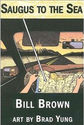
"I fold up the paper, put the sections back in order and grab the '53 Thompson Guide. I suddenly feel like taking a long ride. Bo at the bike shop told me to check for fire roads in the Santa Susanas, a range of mountains just east of I-5. I scan the map. The road names read like a history of land-use in the mountains: Standard Oil Fire Rd. Compressor Plant Fire Rd. Limekiln Canyon Rd. I notice a little dotted line. The old boundary line of the Rancho San Fernando from back, when Alta California was divided into enormous ranchos granted to Spanish nobles. I'm surprised to see it on the map. A phantom boundary, a rune, a warning to those how put too much stock in the permanence of borders. Then a fire road catches my eye. It's labeled Saugus to the Sea, a line that twists through the mountains, east to west, and right off the map. I like the sound of that. A secret road to the sea, a backroad for exiles and refugees from Saugus; hollow-eyed survivors of tract houses and cable TV. A secret road to the far edge of the continent, and a banana boat moored near Oxnard. Then you stow away, and sail west, to the next Promised Land over. That's the road."
From "Saugus to the Sea" by Bill Brown, Smart Cookie Publishing, Vancouver, BC, Canada, 2001, p. 48.
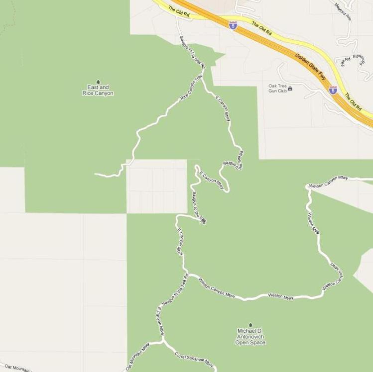
East Canyon Mountainway / Saugus to the Sea Road (from Google maps)
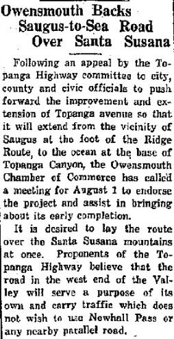
Have you ever wondered about the Saugus to the Sea Road? Well I have. It was supposed to start in Saugus, run south through the Santa Susana Mountains, cross the San Fernando Valley, and run through the Santa Monica Mountains to the sea. Topanga Canyon was the road through the Santa Monica Mountains, and its construction was completed or in progress from the sea to the north San Fernando Valley in the 1920's and 30's. But what happened to the section through the Santa Susana Mountains? To try to trace its history, I have combed the internet for any information.
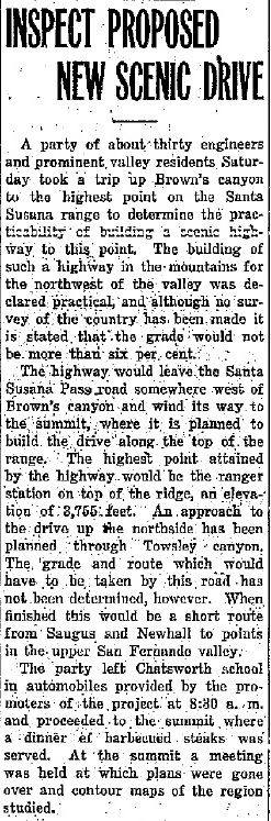
The earliest reference that I could find was from the Van Nuys News of 3/30/1926 (see below). The planned route through the Santa Susana Mountains was just west of Brown's Canyon in the San Fernando Valley running north to the top of the mountains and then east until it would run north down into Towsley Canyon. Brown's (also labeled Browns) Canyon starts at the end of De Soto Avenue north of the 118 Freeway. There is actually a fire road there now called Browns Canyon Road. It runs north up the ridge to the west of Browns Canyon and eventually runs into the Oat Mountain Mountainway Road, also called the Palo Solo Truck Road. From there, the road runs east, just as the Saugus to the Sea Road was planned. However, there is no fire road down into Towsley Canyon.
Topanga Canyon road being improved with the plans to Saugus still alive. From the Van Nuys News of 6/21/1927.
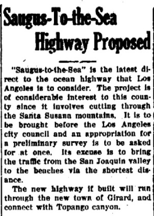
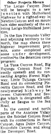
"Saugus-To-The-Sea" proposed. From the Oxnard Daily Courier of 3/28/1927.
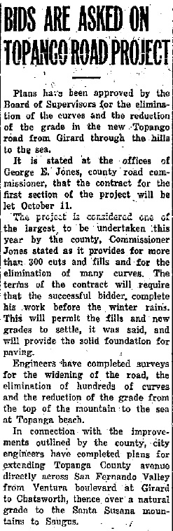
From the Los Angeles Times of 5/6/1927 (top) and the Van Nuys News of 5/27/1927. Apparently, nothing has been done on the road through the Santa Susana Mountains for the past year. But Topanga Canyon Drive is progressing nicely. Girard is the original name of Woodland Hills and Owensmouth is now called Canoga Park.
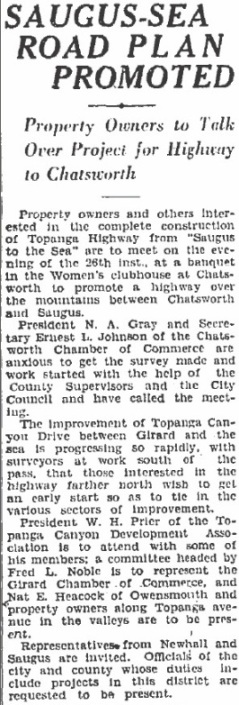
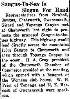
Some are pushing the county to get the road completed. From the Van Nuys News of 6/21/1927.
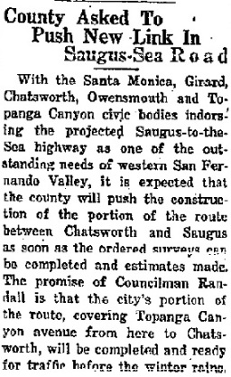
Still pushing. (Owensmouth is now Canoga Park.) From the Van Nuys News of 7/26/1927.
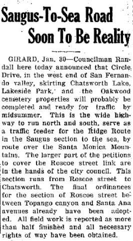
Jump ahead six months. No construction in Santa Susana Mountains yet, but today's Valley Circle Blvd. is almost completed. (Girard is now Woodland Hills.) From the Oxnard Daily Courier of 1/30/1928.
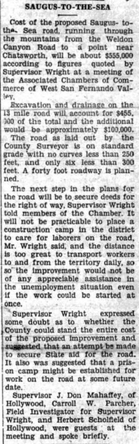
The project sits until February of 1931. From the Signal of 2/19/1931, construction costs for the road are estimated to be $555,000. It is doubtful that the county can afford that much money. The next step would be to obtain right of ways. The use of Towsley Canyon for the road does not seem to be planned anymore. Connecting to the Weldon Canyon Cutoff Road of the state highway (today's Golden State Freeway) would probably put it on the current East Canyon Road, where it is marked on the map at the top of this page.
The Van Nuys News of 3/19/1931 says that the city will start surveys for the road immediately.
The Signal of 4/16/1931 says that deeds for the right of way have been prepared.
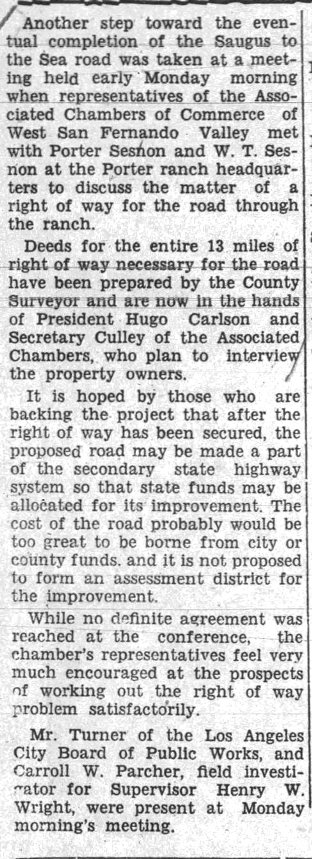
The Van Nuys News of 5/21/1931 reports that the city wants the survey started.
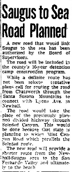
I could not find any mention of the Saugus to the Sea Road until I found this article from the Van Nuys News of 10/16/1955, nearly 25 years since the last article. Now the Board of Supervisors has approved the road, but it has no definite route except that it may link up with Lyons Avenue. It sounds like a new proposal.
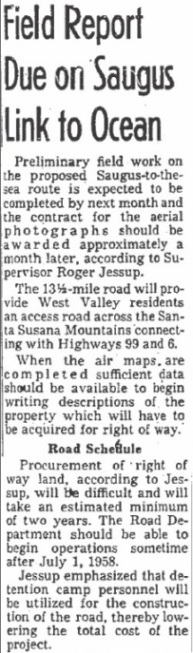
From the LA Times of 1/24/1956. It sounds like 1931 again.
An article entitled "Making Use of Prisoners" in the Van Nuys News of 2/24/1959 reporting on roads using prisoner labor, it is reported that the Saugus to the Sea Road is "newly-started".
Mention of the road vanishes until a letter to Street Smart from the Los Angeles Times of 7/19/1993. Here we finally discover that the Saugus to the Sea Road was finally eliminated from the state highway system plans by Governor Edmund G. Brown Jr. during his first stint as governor.
Chatsworth-newhall link: the road that never was
Dear Street Smart:
There is a real need for roads to link the Simi, Santa Clarita and west San Fernando valleys. Years ago, several plans emerged, including the Chatsworth-Newhall State Highway. Although the route was laid out, it was removed from state highway system plans by Gov. Edmund G. Brown Jr.
The Chatsworth-Newhall State Highway was to start at De Soto Avenue and the Simi Valley Freeway, crossing over the Santa Susana Mountains west of Oat Mountain, with one leg going northeast to Newhall and the other west to Val Verde. A leg from Simi Valley would join the crossover west of Oat Mountain to form a giant "X" connecting the four areas by direct routes.
The same story is also in a letter to the editor from the Los Angeles Times of 8/20/2000.
Connecting roads
B.W., in her letter Aug. 13 ("Growth and Development," Letters to the Valley Edition), called attention to the need for a highway between Chatsworth and Santa Clarita. Actually Gov. Jerry Brown (governor from 1975-1983) removed the Chatsworth / Newhall highway from the state highway system. The Saugus to the Sea, Reseda to the Sea and Knudsen Parkway met a similar fate.
Thus ends our trip on the Saugus to the Sea Road. It started in 1926 and ended around 1980, a trip of over 50 years. The road is still marked on some maps and some may still be searching for it.
"I went looking for Saugus to the Sea the other day. Drove along the Old Road, south of Calgrove and parked on the shoulder across from Rice Canyon. According to the Thompson '53 I should have been looking right at it. But nothing. No fire roads. Just a line of barbed wire and, beyond that, high scrub and, beyond that, the steep rise of the Santa Susanas. I tramped through the chaparral a while till my calves were scraped up. No luck."
From "Saugus to the Sea" by Bill Brown, Smart Cookie Publishing, Vancouver, BC, Canada, 2001, p. 63.