Early Elsmere Canyon Settlements
Tataviams
The Tataviam came to the Santa Clarita valley around A.D. 450 and eventually settled in an estimated 20 - 25 semi-permanent villages. The last full-blooded Tataviam, Juan Jose Fustero, died in 1921. Very little is known of them. The Don Gaspar de Portola expedition of 1769 evidently found a village located in the area where Elsmere creek and Newhall creek used to meet, which would be near the present day Eternal Valley Memorial Park on Sierra Highway. It was named Tochonanga. Tochonanga was one of the Native American villages listed by mission historian Fr. Zephyrin Engelhardt. On May 28, 1864, Henry C. Wiley obtained a lease from Jose Ygnacio Del Valle for the land "known as Tochenanga." The main part of Wiley's ranch was located at the mouth of Elsmere Canyon on the west side of the Newhall creek about where Elsmere creek joined it. Wiley's ranch would be known as Lyon's Station after Sanford Lyon took over in 1869. With all the construction in the area, including Highway 14, any traces of the original village were destroyed.
See "The Tataviam: Early Newhall Residents" by Paul Higgins for more information. Also see the Tataviam website here.
China Gulch
From "Mining Camps of the Soledad" by Arthur B. Perkins, Part 1, The Historical Society of Southern California Quarterly, June 1958, Vol. XL, No. 2, page 160 comes this:
"In 1876, when the Chinese working force was released on completion of the railroad, some of them joined in working a location a couple of miles southernly from Newhall, variously known as China Gulch, or chinese Camp, just east of Highway 6 or northeast of Lyon Station, which was at the present junction of San Fernando Road (to Newhall) and State Highway 6."
Perkins credited a Mr. Curtis Lewman of Newhall for the information. The Chinese were prospecting for gold. Northeast of Lyon's Station would be closer to Placerita Canyon, where gold was actually being found, not in Elsmere Canyon.
Jerry Reynolds, in his "Application for Registration of Historical Landmark", 1993, on page 2 and 11, moves the prospecting location, known as China Gulch, into Elsmere Canyon and even puts it "adjacent to La Puerta" (for more info on La Puerta see my La Puerta page). He also reports still-visible mine shafts. This appears to me to be another example of Reynolds creating his own history to save Elsmere Canyon from the dump. To my knowledge, no gold has ever been found in Elsmere Canyon, La Puerta was not in Elsmere Canyon, and I have never found any mine shafts there.
From "Overseas Chinese Placer Mining Sites in the Santa Clara River Watershed: Documentary Evidence, Archaeological Implications, and Significance" by Jason Marmor, Pacific Coast Archaeological Society Quarterly, Vol. 34, No. 1, Winter 1998:
"The earliest documented gold mining activity in California (1841-42) occurred in Placerita Canyon, the mouth of which opens westerly toward the location of present day Newhall. Mexican prospectors made the initial discovery, and placer mining was conducted sporadically for many decades by Mexican, American, and later, Chinese miners. Several references testify to the presence of Chinese engaged in placer mining in Placerita Canyon during the latter years of the nineteenth century.
According to Mr. Curtis Lewman of Newhall, some of the Chinese laborers who had completed building the San Fernando tunnel and laying track for the Southern Pacific Railroad line to Los Angeles, engaged in mining at a location "a couple of miles southerly from Newhall, variously known as "China Gulch," or "Chinese Camp," just east of Highway 6 or northeast of Lyon Station, which was at the present junction of San Fernando Road (to Newhall) and State Highway 6" (Perkins 1958:160). Based on the above description and the known location of Lyons Station (Grenier 1978:311), the Chinese mining activity occurred along the lower (western) end of Placerita Canyon. They reportedly worked the gravels on the "mesa between Whitney and Quigley Canyons" (Perkins 1958:160). This indicates that the location of "China Gulch" or "Chinese Camp" was actually on the margin of Placerita Canyon since Whitney and Quigley Canyons straddle Placerita Canyon with Whitney Canyon paralleling it to the south and Quigley Canyon to the north.
The location described by the informant, Mr. Lewman, corresponds closely with another description of Chinese mining activity in Placerita Canyon published in a contemporary account by mining engineer E.B. Preston (1890:200-201). Preston explored the canyon in 1889 as a field assistant of the State Mineralogist and reported on the geology and mineral resources of Los Angeles County. He noted that in the portion of Placerita Canyon within Section 5 of Township 3 North, Range 15 West (S.B.M.) where a vein of limestone was exposed there was visible evidence of placer mining activity. Preston went on to state that "on inquiry we found that the Chinese work here during the wet season" (Preston 1890:201)."
This pretty much kills the idea that China Gulch was in Elsmere Canyon. (Marmor's sources: Perkins is the same article I quoted; Grenier, J.A., 1978, editor-in-chief, "A Guide to Historic Places in Los Angeles County", Kendall/Hunt Publishing Company, Dubuque, Iowa; Preston, E.B., 1890, Los Angeles County, in "Ninth Annual Report of the State Mineralogist", California Mining Bureau).
Elayon/Flayon
According to Jerry Reynolds ("Application for Registration of Historical Landmark", 1993, page 13), at the turn of the century a black resort was started in Elsmere Canyon called "Flayon". Directors of the community included Sidney P. Dones and Charlotte Bass. It failed quickly. The dump EIR mentions that the father of a Mr. C. Darryl Haskell once owned a lumberyard and recalled making delivery of lumber to this community and it was located north of Elsmere Canyon.
However, Reynolds was wrong (again). According to many sources (for example the California Eagle of March 13, 1947, The Signal of December 3, 1964, and the Los Angeles Times of March 2, 1994) the resort town of Eureka Villa was founded in the Santa Clarita Valley (miles northwest of Elsmere Canyon) in 1924 by a group including real estate agent Sidney P. Dones (1888-1947), Charlotta Bass, community leader Hattie S. Baldwin, and Norman O. Houston. It became known as "the black Palm Springs" and prospered until the 1960's. One of the tracts of Eureka Villa was called Val Verde. At some point in time (and it is difficult to pinpoint when), the whole area becam Val Verde.
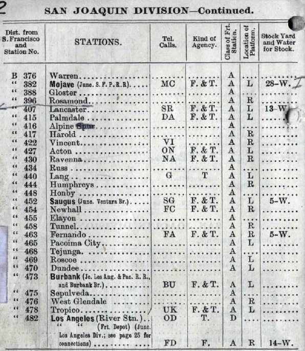
As to Flayon, the following map does shows a "Flayon". It is in Railroad Canyon a few miles west of Elsmere Canyon. The next map shows an "Elayon". This is a real train siding that is mentioned on the Standard Oil website as where oil was piped to and loaded on trains. The locations of Flayon and Elayon are somewhat different on these maps, but the names are so similar (and unusual) that I think there is a mis-print on the first map and both are the same place. The earliest mention of Elayon that I could find is in the Southern Pacific System List of Officers, Agencies and Stations of 12/24/1898. It shows that Elayon was 1 mile from Newhall, three miles to the Tunnel, and 8 miles to Fernando (see below). Elayon wasn't an early name for Newhall and it wasn't Andrew's Station, which was located nearby. It was only a railroad siding. At some point in time, a 1000 foot spur was built to the loading area of the refinery and oil was still shipped from the tanks near the refinery right up until 1943.

"Flayon" on the 1903 U.S.G.S. Camulos topographic map.
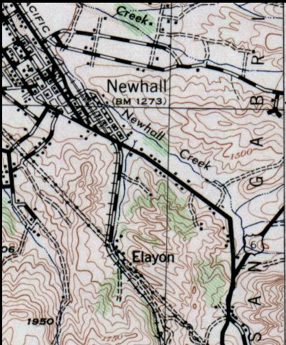
"Elayon" train station from the U.S.G.S. Santa Susanna Quadrangle edition of 1903 (surveyed in 1900).
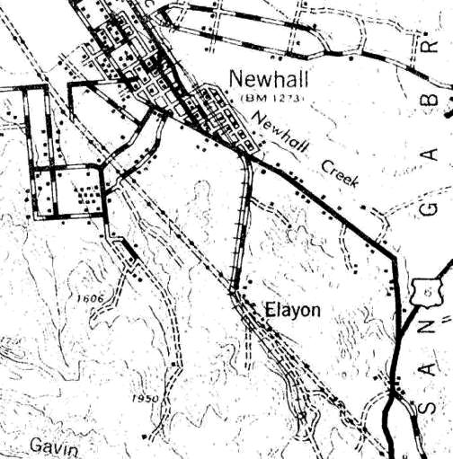
"Elayon" from the U.S.G.S. Santa Susanna Quadrangle map of 1941

Elayon train problem from the Oakland Tribune of March 25, 1903.