La Puerta (The Door)
This page is about La Puerta, but none of the photos show La Puerta. La Puerta is gone. It was graded away during the construction of the Antelope Valley Freeway (Highway 14) and it's location is now on the east slope of that freeway. The photos show an interesting geological feature of a fork in Elsmere Canyon up the northeast tributary. It is located about 1.3 miles, as the crow flies, from the assumed location of Lyon's station at the existing Eternal Valley Cemetary off of Sierra Highway.
La Puerta (the door) was a narrow part of the road between Rancho San Francisco and the San Fernando Valley. So many cattle inhabited the Rancho in the early 1800's, that a fence (or bar) was placed across the narrow part to keep them from wandering into the San Fernando Valley.
Rancho San Francisco was granted from Governor Juan B. Alvarado to Antonio Del Valle on Januay 22, 1839. Part of the description in the grant said: "On the South by a line drawn from said tree to the East through the hills until it reaches the door (La Puerta) or bar which is in the high road from San Fernando to San Francisco at the very foot of the cuesta of San Fernando where the road is very narrow and where it was formerly completely fenced by bars tied to an Oak Tree (Encino) the mountains coursing down on either side and leaving a very narrow pass."
In 1865 and 1868 deeds pertaining to Rancho San Francisco (William Wolfskill to Ygnacio del Valle, March 18, 1865, Book 7, p.104; Thomas R. Bard to Robert H. Gratz, March 29, 1865, Book 7, p.180; Robert H. Gratz to the Philadelphia and California Petroleum Co., September 16, 1868, Book 13, p.47), part of the description of the rancho contained:
"...on the South by a line drawn down said tree to the East through the hills until it reaches the door (la Puerta) or bar which is in the high road from San Francisco to San Fernando at the very foot of the Cuesta of San Fernando where the road is very narrow and where it was formerly completely fenced by bars tied to an oak tree the mountains coming down on either side and leaving a very narrow pass."
In the 1873 deed record of the Philadelphia and California Petroleum Co. to Charles Fernald (Book 26, pp. 330-336), that part of the description was shortened to:
"...East two hundred and fifty six chains to an oak tree marked "S.F." 5, being the point called "La Puerta," at the foot of "San Fernando Pass"
These descriptions plus the maps (see below) clearly show that La Puerta was not in, or particularly near to, Elsmere Canyon.
Here's how A.B. Perkins described La Puerta (here called La Puerca) in a Daily Signal article ("The Rough Road Behind Us") of March, 1964:
"By the time the Butterfield Stages were operating (1858), a new trail (starting at today's Tunnel Station) went over the only reasonable hogback in the range to the crest, and through a shallow cut, then wobbled on the skyline easterly to the original trail down the north slope. It wasn't good - but it was a big improvement. Near the foot of the north slope (nearly in today's Elsmere Canyon) the trail passed "La Puerca" (the gate) in a narrow arroyo that could be - and was - spanned by a couple of saplings, in such broken country that this one short barrier was adequate range fence between the herds of the Mission ranch and the herds of Rancho San Francisco."
He was wrong. It was not "nearly in today's Elsmere Canyon."
In Grizzly Bear Magazine, February 1908, there is an article entitled "El Camino Real vs. State Road" by Mrs. A. S. C. Forbes (Secretary, El Camino Real Association). She writes:
"There was but one pass (now Fremont Pass) known to the padres that led into the head valley of the Santa Clara river and that was early closed to all travel by a secure fence which permitted of no passage by man or beast. This fence was placed there in 1797 and remained until 1822 and when it was at last torn down there was no road built throught the pass until our government troops made one."
In 1993 the Jerry Reynolds, curator of the Santa Clarita Historial Society, tried to get a creek fork in Elsmere Canyon designated as a State of California Historical Landmark, which he called "La Puerta Del Camino Viejo" - The Door of the Old Road. Reynolds writes in the landmark application:
"A curious spine of sandstone and weathered rock extended across the canyon, almost closing it off. It was named La Puerta ("The Door"), becoming something of a landmark in those early days. A couple of logs, laid across the narrow opening, prevented cattle from straying over the mountains from one mission land holding to another."
That statement may be true about the real La Puerta, but it is totally false about what the application claims is La Puerta. How did a fork in Elsmere Canyon become "a spine of rock extended across the canyon, almost closing it off"? It is just one many false statements in the application about the fork in the canyon that Reynolds claimed was La Puerta. Reynolds apparently was so desperate to stop the proposed dump that he ignored the old maps of Rancho San Francisco which showed the location of both the old road and La Puerta. He also ignored the fact that any cattle wandering up Elsmere Canyon had no way out except by returning the same way they came in. However, the dump was stopped, but the landmark designation failed. The landowner had to agree to the historical designation, but the dump company landowner did not agree.
If you ever hike Elsmere Canyon take the left fork and continue up to the so-called "La Puerta" site, which is at another fork in the creek bed. It can't be missed, although it may be difficult to get to. At the false La Puerta site, if you go up the left fork you will eventually run into a 50-foot water. If you go up the right fork, you will be stopped by smaller waterfalls that are nearly impossible to get over. Why would anybody need to stop cattle from going up two forks to nowhere except higher ground? Neither lead to the San Fernando Valley or the Santa Clarita Valley.
The real La Puerta is long gone. It was located somewhere under Highway 14. In an effort to stop the world's largest dump in Elsmere Canyon, La Puerta was moved into Elsmere with an attempt to make it a historical landmark. The landmark designation failed, but approval for the dump also failed. Elsmere Canyon is now open space for the public.

Here is the first documentation of the fork falsely called La Puerta. This is from the Ninth Annual Report of the State Mineralogist for the Year ending December 1, 1889, p. 205-206.
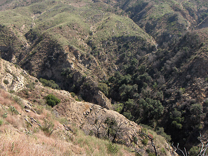
From above. It would be impossible for a stagecoach road to come down from the right (east) to the creek bed and then go up to the left (west). It is way too steep on both slopes. Also, it would be going in the wrong direction. (Photo taken on 3/10/2007)

From another angle (3/10/2007)
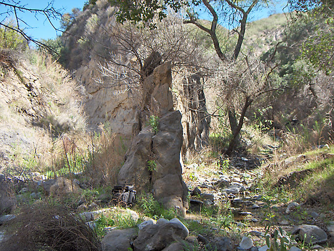
At the bottom looking directly at the fork (3/10/2007)
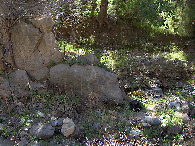
Another view of the fork (3/10/2007)
Filled up with sediment and ash after the November, 2004 rains. The plant life on the slopes was burned away after the July, 2004 Foothill fire. (4/12/2004)
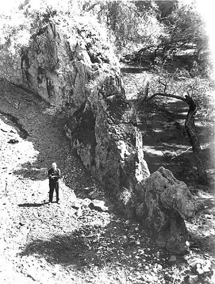
This is a 1963 photo of A.B. Perkins at, what Reynolds claimed, was "La Puerta". Notice how the canyon is filled in with sediments. There was a major fire in Elsmere Canyon in 1962. I wonder if this is the reason the bottom is not rocky like it is now (2004) - the 1962 file burned the hills and the 1962-63 rainy season filled in the canyon. After the 2004 file, the canyon bottom also filled in with sediments (see above picture). Note also the lack of plants as compared to the next picture. (Photo used by permission of the Santa Clarita Valley Historical Society.)
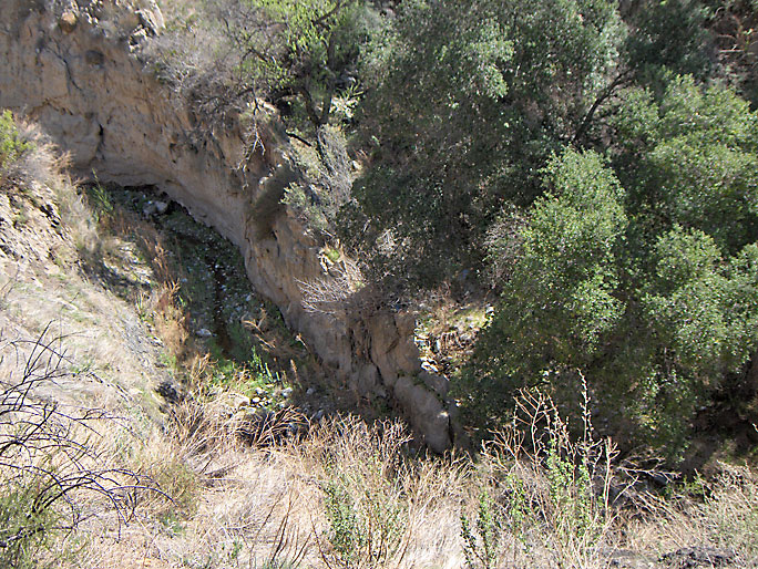
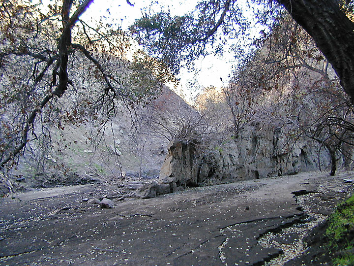
Looking down like the above picture. The plant life made it impossible to recreate previous 1963 picture. (3/10/2007)
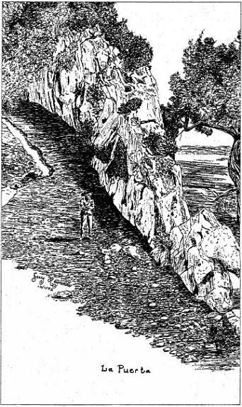
This is a Jerry Reynolds sketch of "La Puerta" obviously copying the Perkins picture from above.
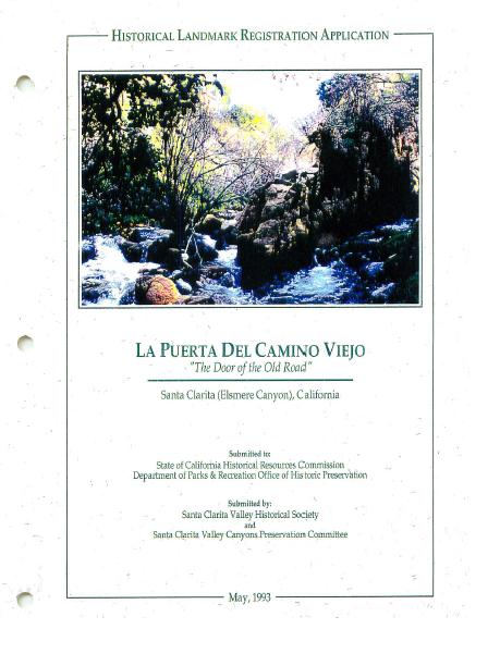
Title page of application for Historical Landmark designation

Early map of southeast corner of Rancho San Francisco from "The San Fernando Pass and the Pioneer Traffic that Went over It" by V. S. Ripley in the March 1947 Quarterly Publication of the Historical Society of Southern California. This is the definitive work on the San Fernando Pass.
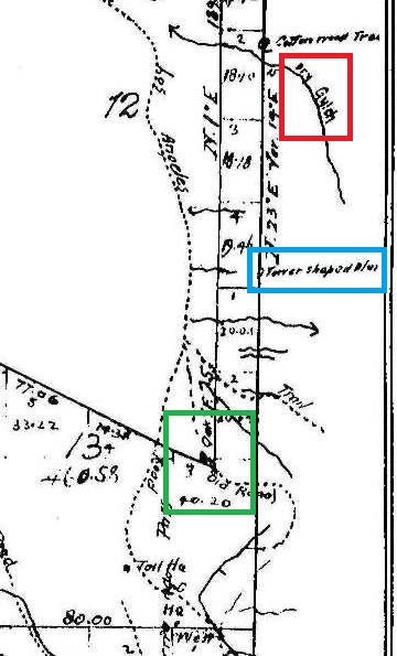
Close-up of map. Based on topographic maps, Ripley said that Elsmere Canyon is "Dry Gulch" in red box at top. The "Tower Shaped Bluff" in blue box in middle of map still exists and is located just east of Highway 14. It can be seen from the highway (see below picture). The southeast corner of Rancho San Francisco is in the green box at the bottom of the map. La Puerta was in there. Unfortunately for history, that area is now mostly Highway 14.
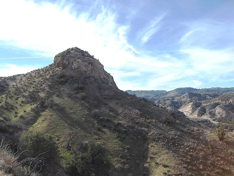
Here is the "Tower Shaped Bluff" from the above map. This view is toward the southwest with Highway 14 in the bottom right of the picture and Elsmere Canyon behind me. The map shows the old road would be where the freeway is today and nowhere near Elsmere Canyon. (1/1/2008)
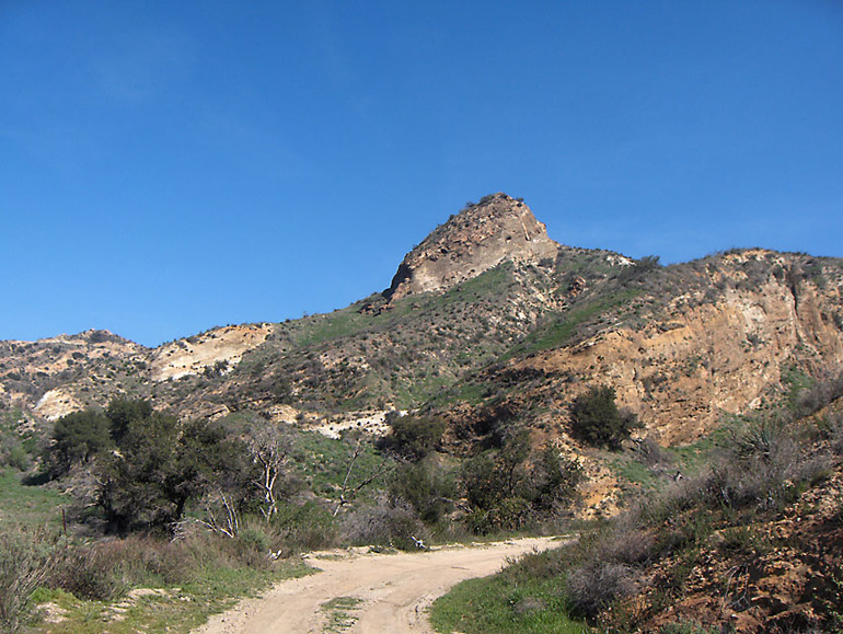
Same bluff from opposite direction. Highway 14 is just to the left of the photo. (2/16/2008)
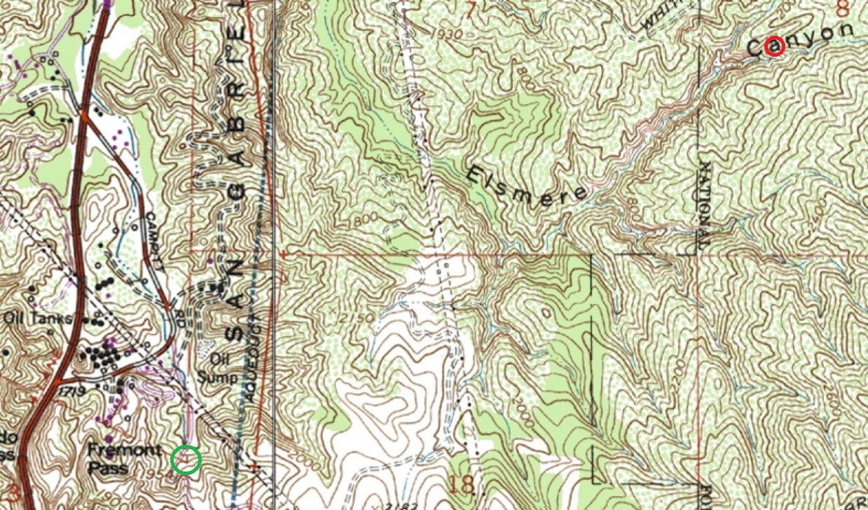
Here is a topo map showing where the real La Puerta is (in green circle at lower left) and where the Reynolds/Perkins false La Puerta is (in red circle at upper right) based on my GPS coordinates taken when I hiked there. Cattle from the Santa Clarita Valley going up Elsmere Canyon can only return the same way they came. It would be impossible for them to reach the San Fernando Valley unless they had wings. This false La Puerta is about 1.5 miles from the real La Puerta. San Fernando Pass (Beale's Cut) is about 1240 feet west of La Puerta.
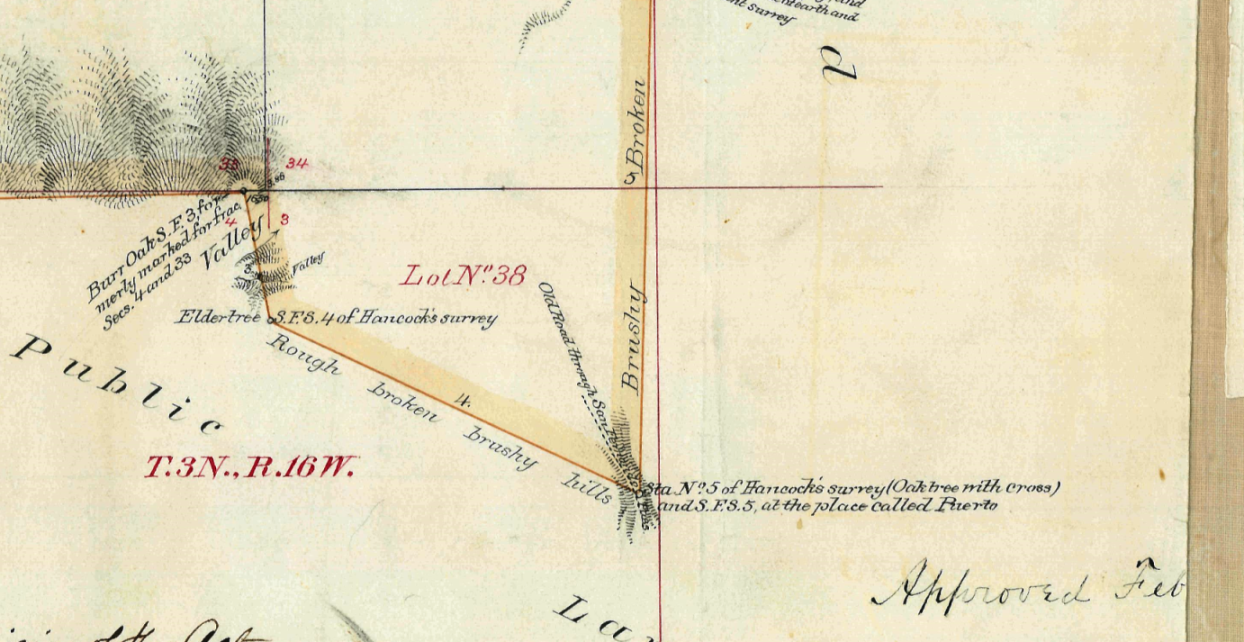
This is the southeast section of the "Plat of the Rancho San Francisco finally confirmed to Jacoba Feliz et al", Surveyed by G.H. Thompson, deputy surveyor, June 1874. Here they call the furthest SE point "Puerto" (which means mountain pass) instead of La Puerta (the door).

Aerial photo showing the Newhall Tunnel, Beale's Cut (or Fremont Pass), and The Old Road with La Puerta on the hairpin curve. The Newhall Refinery had just opened in early 1930. The future 14 Freeway would be between Beale's Cut and La Puerta. La Puerta would be cut away by grading for the east sloop. (FrameFinders website, Fairchild Aerial Surveys, Image c-1001a a-267, Taken July-August 1930.)