Brief History of Oil Development in Whitney Canyon


This topo map shows most of the well sites in Whitney Canyon. Coordinates from DOGGR records.


There were over 24 wells drilled in Whitney Canyon (I left out some wells that are east of, or under, Highway 14). There are few records of the wells drilled before 1916, when the Division of Oil and Gas (DOG) was created by the state along with new reporting laws.

The first well was drilled in 1893 by Banner Oil Company. The Los Angeles Herald of September 11, 1891 reported that:
The Banner Oil Company filed articles of incorporation yesterday with the county clerk. The purposes for which it is formed are to purchase, lease and develop oil lands, etc. The directors are C.S. Sprecher, C.T. Dondore and C.U. Tyke, of San Diego; C.W. Maxson, of Oceanside; P.L. Abel, W. Chambers, W.A. Vandercook and T.A. Schmidt, of Los Angeles, and W.A. Brophy, of Newhall. The capital stock is placed at $250,000, $125,000 of which has been subscribed.
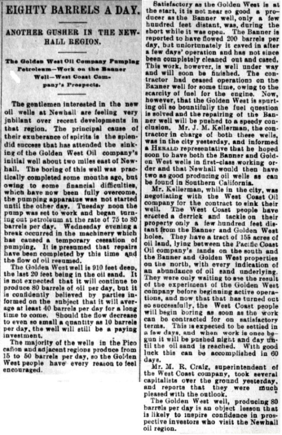
Banner 1 was drilled in 1893 to 800 feet and reportedly produced about 125 barrels of oil in 8 hours, but water and quicksand broke into the well and it was abandoned (12th Report of State Mineralogist, 1894). However, a newspaper article (see below) reported that Kellerman was attempting to clean out and case the well. There is some confusion about the first three Banner wells. They were all apparently drilled before 1900 and then redrilled between 1917 and 1921. Walling (1934) says the well numbers were changed (1 to 3, 2 to 1, and 3 to 2) by Republic Oil Company around 1920, but I don't see that documented in DOG records, so I don't show that in my table of wells drilled (listed below).

In 1894, Golden West Oil Company drilled the second well just west of Banner 1. It reportedly had a good showing of oil but it could not be pumped due to quicksand. The well had to be abandoned.

The Nettleton & Kellerman Oil Company drilled three wells by the early 1900's. D. A. Connell drilled three wells before 1910. Oil seeps on the slopes south of the canyon attracted early drilling, but most of the wells were unproductive. Seeps still exist on the south slopes of the canyon. According to Oakeshott (1958), the area produced a few thousand barrels of oil from 1893 to 1937.

In 1934, Walling was the first to suggest a fault in Whitney Canyon in the Summary of Operations, Vol. 20 No. 2. He wrote (and see his map below):
A fault probably exists between well No. Banner 2 and the other two wells shown on the section. Well No. Banner 2 failed to find the upper and lower sands found in the other wells.
What that basically means is that no oil was found east of the fault, which has been extended north to Placerita Canyon and south past Elsmere Canyon by later geologists.

In 1970, the Atlantic Oil Company drilled the last new well in Whitney Canyon - Albert 1. No commercial quantities of oil was found, so the well was abandoned.

The most interesting well was Phillips 1, drilled by Continental Oil Company in 1952 to a depth of 8253 feet, the deepest well ever drilled in the canyon. This well penetrated the productive oil sands of the Placerita field (called the Kraft sands) at 435 feet. At 1305 feet, it entered Eocene rock until 5940 feet. After passing through 150 of fault gouge (the Whitney Canyon fault), it reached basement gneiss at 8253 feet. No commercial quantities of oil were found.

In 2007, the DOGGR capped Albert 3-A, which was located on a road running north from the Whitney Canyon Parkway less than one mile from the parking lot just past the road into Elsmere Canyon. That was the last visible well in the Whitney Canyon area. The Whitney Canyon area was never very productive.

Geologically, the Whitney Canyon formations are the Saugus, the Pico Formation below that, an Eocene age formation below that, and the basement complex. The oil comes from the Pico formation and the unnamed Eocene age formation. (In Elsmere Canyon, the Eocene was called the Juncal formation by Squires).

The best year for Whitney Canyon was 1933 when production was 4,347 barrels of oil.


Table of the wells drilled in Whitney Canyon

(From Walling, 1934, Oakshott, 1958, and DOGGR records)
Drilled By Original Well # Last Owner Last Well # Total Depth Spud Date Remarks
Banner Oil Co Banner 1 Atlantic Richfield Co Banner 1 800 1893 Water broke in - abandoned
Golden West Oil Co Golden West 1 Santa Clarita Watershed Golden West 1 930 1894 250b/d for 1st 4 days; water broke in - abandoned
Banner Oil Co Banner 2 Atlantic Richfield Co Banner 2 850 1899 (?) Redrilled in 1919 by Republic to 1020'. Never produced.
Banner Oil Co Banner 3 Occidental Petroleum Co Banner 3 850 1899 (?) Water broke in original well. Redrilled in 1921 by Republic to 1020'. Never produced.
Nettleton & Kellerman Oil Co Fink 1 Occidental Petroleum Co Fink 1 1450 1899 After initial prod, declined to 2-3 b/d
Nettleton & Kellerman Oil Co Fink 2 Occidental Petroleum Co Fink 2 1500 1900 Never produced
Nettleton & Kellerman Oil Co Kellerman 3 Occidental Petroleum Co Kellerman 3 ? Pre-1904 No DOG records
Yankee Doodle Oil Co Yankee Doodle 1 Republic Petroleum Co Yankee Doodle 1 705 1900 Abandoned sulpher water well per Republic 1920 document
D.A. Connell Connell 1 Santa Clarita Watershed Price 1 950 1908 Brownish-green oil below 835ft
D.A. Connell Connell 2 Santa Clarita Watershed Price 2 1100 1908? Water broke in - abandoned
D.A. Connell Connell 3 Occidental Petroleum Co Price 3 650+ 1909? Producing as of 1934
Tunnel Petroleum Co No. 2 Republic Petroleum Co No. 2 1386 1917 Never produced.550' from Banner 1
California Newhall Oil Co No. 1 California Newhall Oil Co No. 1 1865 1920 Never produced
Southern Production Co No. 1 Occidental Petroleum Co Price 4 2842 1930 2 b/d oil, 5 b/d water
H. C. Hicks Lillie 1 H. C. Hicks Lillie 1 1000+- 1930 Shown on Walling 1934 map-DOG records have a different location not in Whitney Cyn
Rothschild Oil Co Phillips 2 Rothschild Oil Co Phillips 2 3000 1950 Never produced - abandoned in 1950
George D Rowan Phillips 3 Oro Negro Inc Albert 3 671 1952 Never produced - redrilled in 1957
George D Rowan Albert 20 Oro Negro Inc Albert 20 1438 1957 Never produced
George D Rowan Albert 3-A Santa Clarita Watershed Albert 3-A 552 1957 100 b/d init prod - 8 b/d after 15 days. Abandoned in 2007
George D Rowan Banner 4 Atlantic Richfield Co Banner 4 1137 1958 Last produced 3 b/d in 1981
Occidental Petroleum Co Albert 103 Oro Negro Inc Albert 103 673 1963 Never produced
Occidental Petroleum Co Banner 5 Atlantic Richfield Co Banner 5 1482 1963 Last produced 1 b/d in 1964
Occidental Petroleum Co Banner 6 Atlantic Richfield Co Banner 6 683 1964 Last produced 2 b/d in 1981
Atlantic Oil Co Albert 1 Atlantic Oil Co Albert 1 1018 1970 Never produced


1904 map from Prutzman, Production and Use of Petroleum in California, California State Mining Bureau,Bulletin 32, 1904. This map shows four Whitney Canyon wells, three are on the Nettleton & Kellerman lease (Fink1, Fink2, and Kellerman 3) and one is on the Banner lease (Banner 1). The Golden West well is not shown.


1913 map from Prutzman, Petroleum in Southern California, California State Mining Bureau, Bulletin 63, 1913. Note the property of J. H. Whitney at the mouth of the canyon.


1934 map from Walling, Summary of Operations, California Oil Fields, Vol. 20 No. 2, Newhall Oil Field. Note that on this map the original Banner 1 is marked as Banner 3. Also note that Walling is the first to show the north-south Whitney fault, just marked as "fault" on this map.


Map 254 from the DOGGR. On my map at the top of the page, I left off wells under, or to the east of Highway 14 and wells north of Banner 6.


Early Banner story from the Los Angeles Herald of January 15, 1893


Whitney Canyon oil story from the Los Angeles Herald of October 2, 1893


Whitney Canyon update from the Los Angeles Herald of October 8, 1893


From the Los Angeles Herald of March 16, 1894


Site of Albert 103 overlooking the Ranger's house. It was drilled in 1963, but never produced oil. (Photo taken on 9/5/2009)


Site of Price 3 drilled around 1909 (9/5/2009)


Some hardware near Price 3 (9/5/2009)


Site of Price 2 drilled around 1908. There is only some dried up petroleum that spilled from the well to indicate the site. (10/3/2009)


Site of Price 1 drilled in 1908. There is no evidence of a well here. (9/5/2009)


Fink 1 site overlooking the man-made pond. The well was drilled in 1899, well before the pond was built. (9/5/2009)


Fink 2 is just past the pond on the north side of the road (based on DOGGR coordinates). It was drilled in 1900. This pipe is close to the site, but DOGGR records say that Fink 2 was plugged to the top of the well and covered with a concrete cap. This is probably just an old water well. (9/4/2009)


On the other side of the road from the pipe sticking out of the ground is this oil seep (9/4/2009)


Most of the seep has dried, but some oil is still oozing out (9/4/2009)


Old casing near the pipe (9/4/2009)


Some of the records say that well Banner 1 was renamed to Banner 3, but the DOG records show that in 1909 Banner 3 was drilled 500 ft from Banner 1, which was drilled in 1893, the first well drilled in Whitney Canyon. This is the road up to Banner 3. I think that Banner 1 was in the gulley to the right of this photo below the road closer to the creek bed. Golden West 1, the second well in the canyon was probably located left (west) of the ridge where this road is and also close to the creek bed. There is no evidense of its existense. (9/5/2009)


In the gulley below the above road is this old wooden tank hoop (9/5/2009)


Here is the end of the road at Banner 3. Banner 4 may have been drilled at this same site in 1930. (9/5/2009)


This elevated site might have been the location of Banner 5 drilled in 1963. There are some artifacts here, so there was definitely a well here. (9/6/2009)


Further north up from Banner 5 is Banner 6, drilled in 1964 (9/6/2009)


Albert 20 was drilled in 1957 (10/3/2009)


Another view of Albert 20 site. The road is on the other site of the creek bed. (10/3/2009)


Albert 1 was drilled deep in the canyon in 1970. It was the last oil well drilled in Whitney canyon and never was in production. Considering there was an Albert 103 and many other Albert wells in the area, it is odd that this well was called Albert 1. (9/4/2009)


This old steel rope is near the site of California Newhall 1 drilled in 1920. (9/4/2009)


These old bricks and oil spill are also near the site of California Newhall 1 (3/27/2011)


This old casing is in the creek bed below the site of California Newhall 1 (3/27/2011)


And here is the California Newhall well site (3/27/2011)


Right off the Whitney canyon Parkway road is this road to Albert 3 and 3A as it looks on 9/12/2009.


Here is the road in November of 2006 with the gate hardware still intact. The plate said "Whitney Canyon Ranch".


This is the site of Albert 3A drilled in 1957. It was abandoned in 2007 after the land was purchased for public use. Albert 3, from 1952, was close by. (9/12/2009)


There is a lot of junk below Albert 3A including this tank (9/12/2009)


When an oil well is abandoned, the casing is usually filled with cement right to the top. These two pieces of casing are both filled with cement. They were just dumped up a side canyon so I have no idea where they came from. However, they could have come from Fink 4 (see Elsmere oil history locations). The top five feet of that well was filled with concrete, but later broke off. (9/5/2009)


Old hardware (9/5/2009)


Old cut nails (9/5/2009)


More cut nails (9/6/2009)


(10/3/2009)


Albert 14 is located on top of the hills to the north of Whitney Canyon. It is in the Placerita Canyon Oil Field. I hiked up a ridge from the bottom of the canyon to the top. This is the closest well to Whitney Canyon still operating. It was spudded (drilling started) in 1955. (10/3/2009)


Reverse view of well toward Whitney Canyon (10/3/2009)